

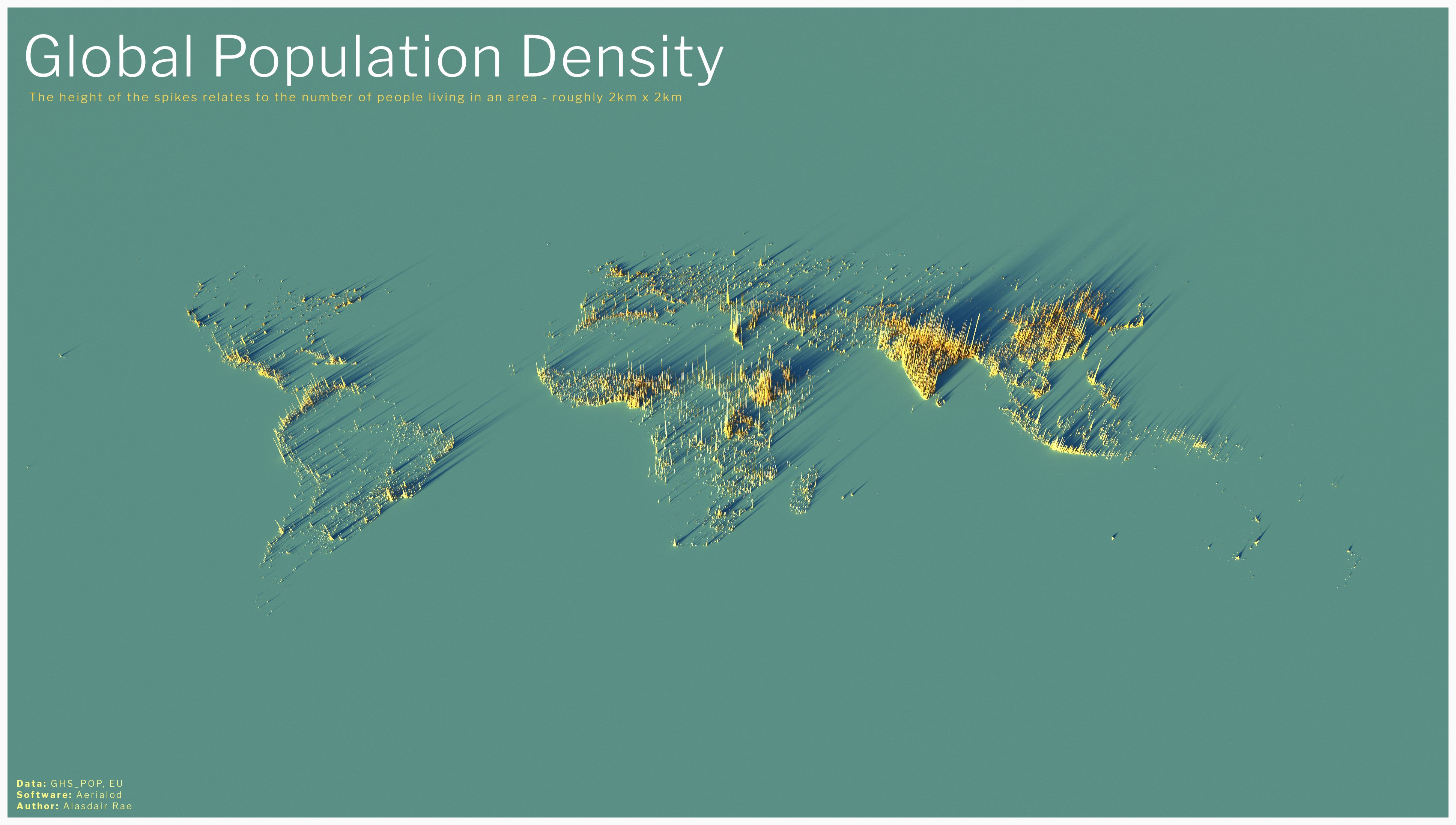
Great visual on how sparsely populated Australia is.
I like how you can just about make out the shape of Australia’s east and south coastlines.
I’m not good at geography, but I’m going to pretend that that’s New Zealand and this is revenge for all the times NZ was left off the map.
But you actually can make out New Zealand!('s North Island.) Auckland is easy to see, and I can just make out Wellington from the preview version. When I look at the full-resolution there are enough dots scattered around to make out the full North Island, plus a couple of the bigger towns on the South Island.
Double New Zealand
But not Canada at all. I figured it would be Australia that would be completely invisible, but nope, Canada.
Not being an island, and having about 90% of the population within 100 km of the US border, really doesn’t do Canada any favours in this illustration.
India jfc
India became the world’s most populous country last April. I didn’t even know that.
Probably had been for a while as Chinese numbers aren’t considered to be reliable
By whom? How could China’s numbers be less reliable than India’s?
I’m in this picture, and I don’t like it
I don’t think I am - and I do like it.
How’s that 8-day trip to ISS going?
Nothing that exciting. I just live in a very small community, quite a distance from any larger community, and I’m pretty sure that at the scale of that map - my community doesn’t exist. If I zoom in enough, maybe there’s something there, but I think it’s digital compression artefacts.
Dang, India needs to find a different hobby.
Imagine what if it would be an Olympic sport? They’d probably take the gold if my ex wouldn’t be competing.
I had no idea Port-au-Prince was so dense. It’s the ninth most densely populated city in the world and top in the Western Hemisphere.
Yet other map ignoring New Zealand.
/s
I get your joke but isn’t it there? Or is this part of Austria? It’s hard to tell but I think New Zealand is there
It’s there. I’d argue Australia is worse off in this map.
Yet it is there. Only continent totally thrown of the edge is Antarctica. I wonder why… just asking questions, not implying any agenda
I don’t think penguins are included in the population count, otherwise NZ would have another 500k population.
I’m pretty sure there’s a Big Antarctica conspiracy to keep penguins off the map, hiding their army of 44m penguins.
Beautiful map!
Ray Tracing to make the data science look good.
👍
This map looks good, but feels somewhat misleading. For me, it looks like India is home to about half of the world’s population.
Still, very beautiful presentation.
India has 17% of the world’s population - on a scale like this image, that’s not far off “about half”! It looks right to me.
The Sahara looks pretty hostile here
Western China too. I flew over it and it’s like an endless mountainous wasteland.
Holy shit i had no idea Ethiopia was so crowded. it’s cool how you can see population swells around the Nile and Lake Victoria too. and the Mediterranean coast of course. and I guess Nigeria is just a good place to live??
This place acts like legends are illegal or something.
Huh, I can read Canada. I call bullshit on the 2x2 thing, though. This is more like 10x10, otherwise you’d see a lot of smaller communities.
It’s mostly not surprising, but laid out like that I wonder how long places out of the historical spotlight have been that populous. Ethiopia is quasi-historical enough we can be pretty sure it’s long been a center, but the African Great Lakes? Who knows.
Let’s take a moment to appreciate that almost every one of those billions of people was someone doing the dirty and the rest were turkey-bastered in :3
Thanks for keeping us on topic, Chief. We almost stopped thinking about sex for a min.
Humor is dead, huh.
Nah, you’re just not funny
You’re humorless but go off.
What was it?
c/mapswithoutnewzealand


